
Researching your House History in Clarecastle
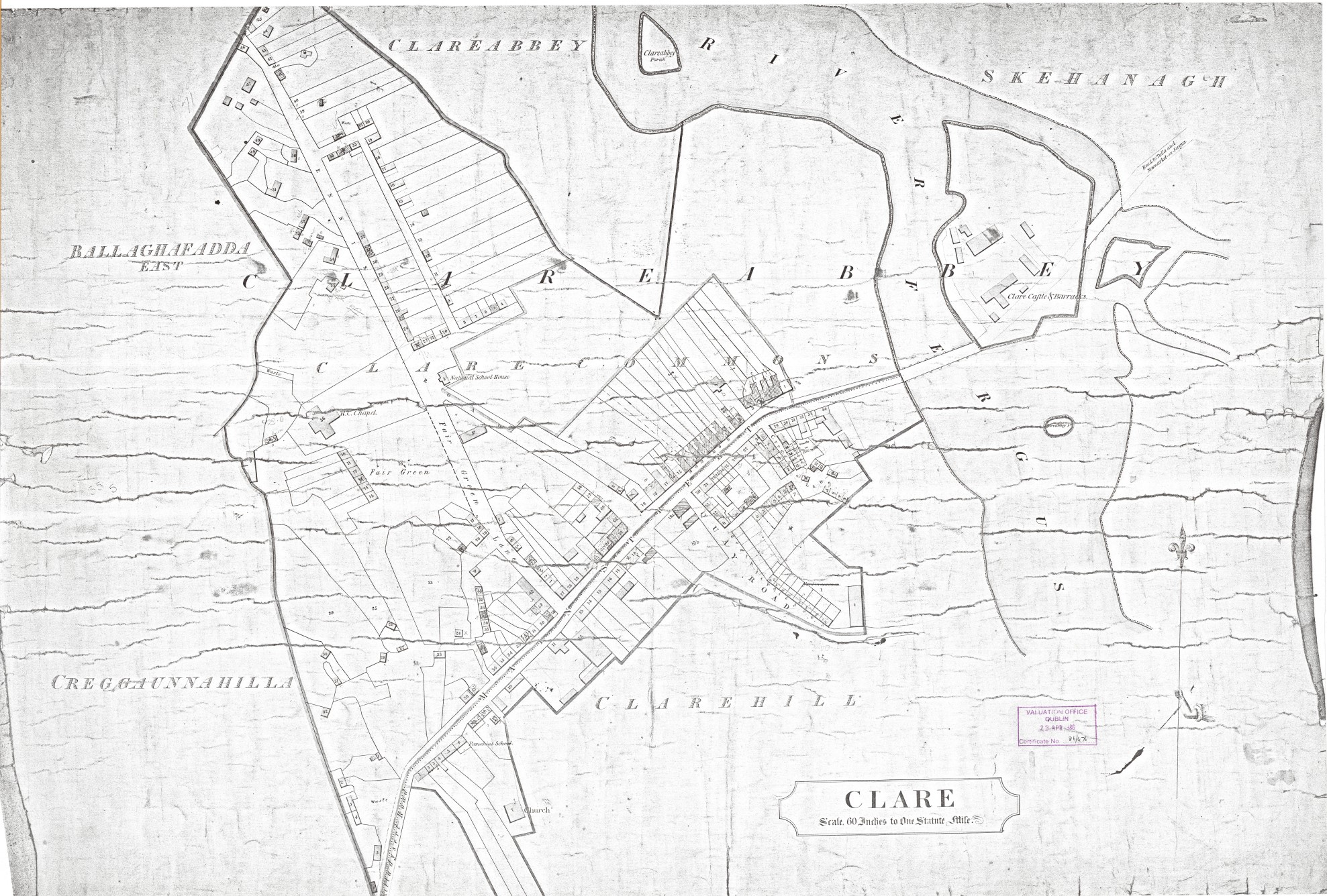
The Village of Clarecastle in built mainly on two large townlands, Clare Commons and Clarehill. In the Griffith’s Map, the Main Street ran all the way from the Bridge to the east and to Enright’s Corner to the west. Clare Commons lies to the north of the Main Street, with Clarehill to the south.
The Griffith’s Map on the website shows the divide of the Village over these three townlands and it gives a number for every house. That number was used as a reference in the Griffith’s Valuation and has been continued up to the present day. So if your house was Clarehill, No. 19, Main Street, in 1855, then it is still that number.
The Valuation Book plot the movement in ownership of the houses from 1855 to the present day. Every time there was a change of tenancy or ownership, the change was noted in a coloured ink in the Valuation Book. As the changes mounted up, the original Book was cancelled and a new book was opened. In the case of Clarecastle, 10 Books now bring you to the present day. The Cancelled Books are currently being digitised by the Land Valuation Office. The Clare Books can be viewed on screen in the Land Valuation Office. When the Land Valuation Office has transcribed Cancelled Books for the country, the files may become freely available.
Creggaunnahilla is a small townland that lies to the west of Clare Commons and Clareabbey townlands lies to the north. Both townlands have been seperately transcribed as part of this project. In time, other townlands such as Ballaghafdda East may be added. Volunteers could undertake this task.
Further information on house history can be found on some of the links below. The Census Returns for 1901 and 1911 are of particular importance. As well as listing the occupants of each house in those years, supplementary forms give details of the house type, number of rooms, outbuildings etc. One can glean a wealth of information on a house from those forms.
National Archives of Ireland, Genealogy
On this micro site of the National Archives, you can access the Census Records for 1901 and 1911, Census survivals for 1821-51, Census Search forms for 1841-51, the Tithe Applotment Books from 1823 to 1837, the Soldiers’ Wills from 1914 to 1917, and the Calendars of Wills and Administrations from 1858 to 1922. All of these records are free to access, through searchable databases and linked images of relevant pages.
The Irish Land Registry is one of the most advanced land registers in Europe. The Registry is fully computerised and all registered land parcels are digitised. Registration is conclusive evidence of title to property.
The Valuation Office has a manuscript archive containing rateable valuation information of all property in the Irish state from mid 1850s until the early 1990s. This archive is recognised as a census substitute for the period from the 1850s to 1901 (the earliest complete census record for Ireland).The archive may be used to trace the occupiers of a particular property over a period of years.
Ask About Ireland and the Cultural Heritage Project is an initiative of public libraries together with local museums and archives in the digitisation and online publication of the original, the unusual and the unique material from their local studies’ collections to create a national Internet resource for culture. It also provides free access to Griffith’s Valuation, the first full scale valuation of property in Ireland, published between 1847-64. Here can view a transcription scan of the original document.


No Comments
Add a comment about this page