
Ballaghafadda East 1855-1970
The developments along the main road between Clarecastle and Ennis in the early to mid-twentieth century is captured in the Ballaghafadda East Primary (Griffith) Valuation of Ireland revision/ cancelled books 1855-1970 and present a microhistory of the social changes which occurred in Clarecastle in the period.
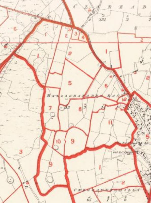
Ballaghafadda East is located north-west of the village, its boundary includes part of the main road to Ennis (R473) and the Conic Line (R473). The townland occupies 113 acres and is surrounded by the townlands of Clare Commons, Creggaunnahilla, Ballaghafadda West and Clareabbey.[1]
The 1855 Griffith Valuation divided Ballaghafadda East into twelve lots. Ballaghafadda East and the neighbouring townland of Ballybeg was part of the estate of John Carroll (1788-1875) of Merville House near Miltown Malbay. He was a Clare born, London based barrister who also held land in other parts of County Clare and County Sligo.[2][3][4] Following Carroll’s death in June 1875 the 1875-1884 revision/cancelled book note that the immediate lessor (landlord) passed to Thomas Crowe of Dromore Woods. There were two Thomas Crowes father Thomas Crowe (1803-1877) and his son Thomas (1845-1922).[5][6][7][8]
As was common in many parts of rural Ireland tenant farmers who held leases on small farms in Ballaghafadda East entered into an agreement to purchase their land under the Land Act Purchase (LAP) and this is shown in changes to the immediate lessors (landlord).
The move from tenant farmer to purchaser and continued link to the same farm is illustrated in the case-study of the twenty-eight-acre farm formed of lots 5, 6a and 7 which was held by Patrick O’Brien in 1855. While there are changes to occupiers’ surnames in the period 1855-1943, this farm was held in three generations of the same family passing from O’Brien to his widow Margaret (nee Meaney 1823-1916) to Margaret’s second husband Charles Roughan (1838-1892) and then to Patrick Cullinan (1861-c1926) who married Anne O’Brien (1856-c1930). Anne was Margaret Meaney and Patrick O’Brien’s only surviving child. After Patrick Cullinan’s death the farm passed to Anne and finally to their daughter Bridie Cullinan (1898-1942) who died unmarried and childless. There are no civil death records for Patrick Cullinan and his wife Anne but the changes to the occupiers listed in the revision/cancelled books assists with locating when deaths occurred. The farm later passed to John Hogan.
The sub-divisions and re-numbering/ lettering demonstrated in lot one is a case study of the housing development in what was a sixteen-acre farm held by the Kelly and later by John Carthy. Lot 1 borders two roads. Sub divisions for houses are recorded providing homes for the expanding community, a feature of development in the parish particularly from the 1960s onwards.
Part of lot 2 was developed to create St Joseph’s Terrace in what was known as Pike’s Field. Later in the 1960s, part of lot 6 was developed for the Abbey View houses near the school. Lot 12 became the site of the new National School which opened in 1935.
The population of Ballaghafadda East showed little change 1901—1911 with twenty-eight people in five households in 1901 and was twenty-four in 1911 still in five households and contrasts with a population of 317 living in 145 houses at the 2011 census of Ireland.[9][10] A series of maps and satellite images available at http://griffiths.askaboutireland.ie/ illustrate the changes to Ballaghafadda East 1855 to present.
[1] (https://www.townlands.ie/clare/islands/clareabbey/clareabbey/ballaghafaddy-east/) (accessed 10 Oct 2021). This website refers to Ballaghafadda East as Ballaghafaddy East.
[2] Landedestates.ie
[3] Edward Walford, The County Families of the United Kingdom, Or Royal Manual of the Titled and Untitled Aristocracy of Great Britain and Ireland; Containing a Brief Notice of the Descent, Birth, Marriage, Education, and Appointments of Each Person, His Heir … Together with His Town Address and Country Residence, Harwicke, London 1864. (available on Ancestry.com and Google Books (accessed 11 Oct. 2021).
[4] Census Returns of England and Wales, 1871/i. Kew, Surrey, England: The National Archives of the UK (TNA): Public Record Office (PRO), 1871. (Ancestry.com) accessed 11 Oct 2021.
[5] Calendar of Wills and Administrations 1858-1920/i. The National Archives of Ireland. http://www.willcalendars.nationalarchives.ie/search/cwa/home.jsp: 13 January 2016. (Ancestry.com) accessed 11 Oct 2021).
[6] (http://www.census.nationalarchives.ie/pages/1901/Clare/Ruane/Dromore/1068322/) (30 Sep 2020).
[7] Clare Advertiser and Kilrush Gazette, 10 May 1877.
[8] (https://civilrecords.irishgenealogy.ie/) (30 Sep 2020)
[9] Censuses of Ireland 1901 and 1911 Ballaghafadda East available at http://www.census.nationalarchives.ie/pages/1901/Clare/Clareabbey/Ballaghafadda_East/ and http://www.census.nationalarchives.ie/pages/1911/Clare/Clareabbey/Ballaghafadda__East/ (accessed 11 Oct 2021).
[10] Clarecastle and Ballyea, Land and People, Author, 2014, p.182.


No Comments
Add a comment about this page